Development Application No. PL2023-045
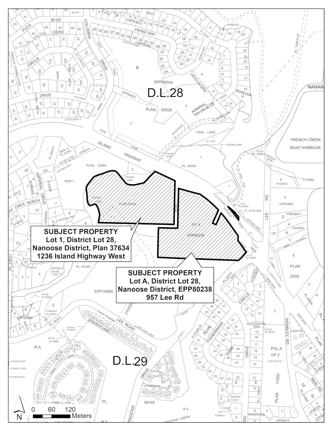
957 Lee Road and 1236 Island Highway West
The RDN has received a zoning and official community plan amendment for the properties legally described as Lot A, District Lot 28, Nanoose District, Plan EPP80238 and Lot 1, District Lot 28, Nanoose District, Plan 37634. The subject properties are currently zoned Public 1 Subdivision District Q (PU1Q) and Residential 1 Subdivision District Q (RS1Q) (see Document Library). Lot A is currently developed with the Regional District of Nanaimo French Creek Pollution Control Centre and Lot 1 contains a dwelling unit. The Electoral Area G official community plan designates the subject properties as Institutional and Neighbourhood Residential.
In summary, the proposal is as follows:
- to amend the Electoral Area G Official Community Plan land use designation that applies to Lot 1 from Neighbourhood Residential to Institutional and Parkland, Greenspace, and Natural Area to accommodate near-term and long-term expansion requirements of the French Creek Pollution Control Centre and for the purpose of riparian protection and potential future community trail use (See Attachment 1 for Proposed Site Plan).
- to rezone the lands from Residential 1 and Public 1 to Public 4 with site-specific provisions that propose to increase the maximum parcel coverage from 10 to 15% to accommodate near-term and long-term expansion requirements of the French Creek Pollution Control Centre .
This is in your community and we want to hear your thoughts on this proposal. A few ways you can learn more and share your thoughts are by:
- Check out our Document Library which includes the site plan and supporting studies
- To see the status of the application and next steps visit our Process
- Visit the FAQ's or Important Links for more information
- Be sure to Register to provide your input
- Share your thoughts on the application in the Application Input tab below
- Submit your questions and we will provide an answer for all to see in the Ask a Question tab below
- Project updates will be shared in the What's New tab as the project moves forward
- Connect with our team by email or phone - see our contact info in Who's Listening
Ask a Question
Have a question about this application? Use this space to ask your question and staff will respond within two business days.
Signup Banner

Document Library
-
 Environmental Study (4.2 MB) (pdf)
-
Preliminary Geotech and Enviro Investigation (7.18 MB) (pdf)
-
Geotechnical Assessment (3.1 MB) (pdf)
-
RAR Assessment (1.18 MB) (pdf)
-
Park Land - Green Space and Natural Areas Land Use Designation (94 KB) (pdf)
-
Institutional Land Use Designation (19.1 KB) (pdf)
-
Neighbourhood Residential Land Use Designation (92.9 KB) (pdf)
-
Public 4 zone (105 KB) (pdf)
-
Public 1 Zone (135 KB) (pdf)
-
Site Plan (1.08 MB) (pdf)
-
 Draft Bylaws
-
PL2023-045 OCP ZA Introduction French Creek Pollution Control Centre.pdf (4.84 MB) (pdf)
-
Public Hearing Notice (870 KB) (pdf)


Who's listening
-
Email gkeller@rdn.bc.ca