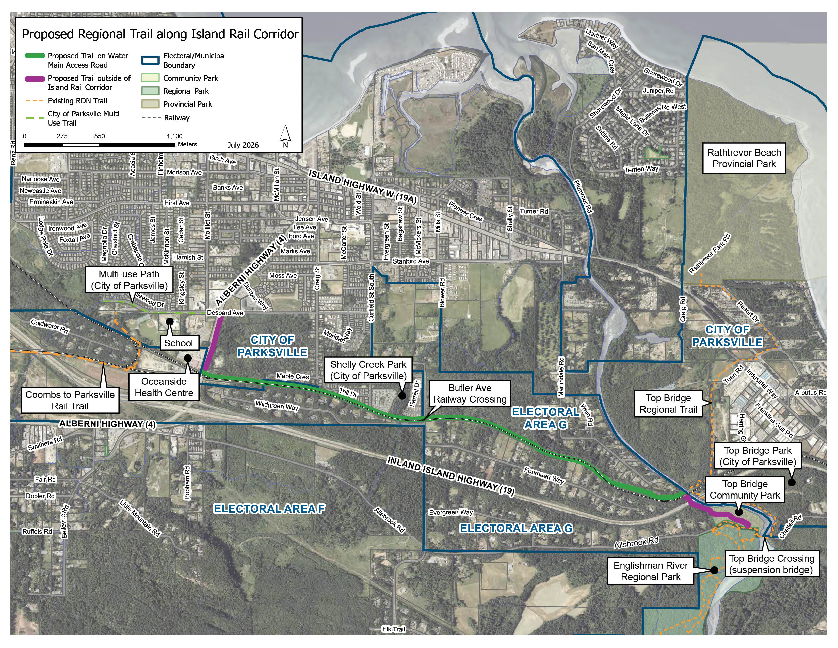
Rail Trail from Top Bridge Crossing to Despard Ave in Parksville
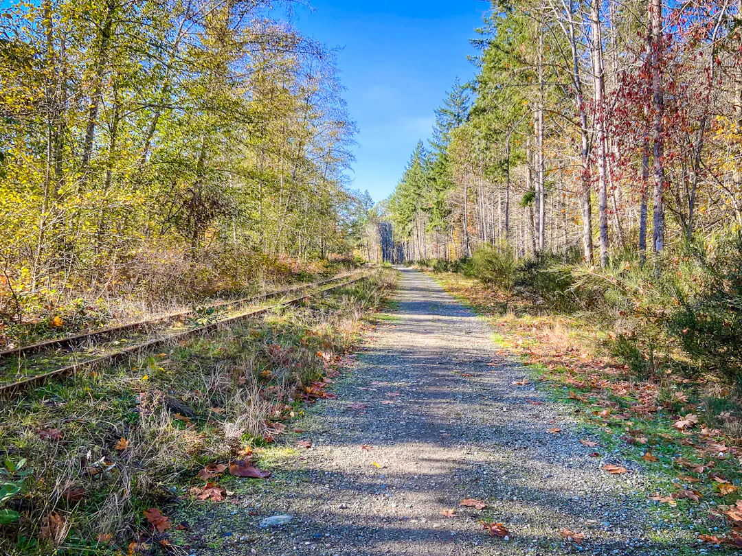
Trail next to railway tracks

The Regional District of Nanaimo (RDN) is planning a new regional trail along the Island Rail Corridor between Top Bridge Crossing and Despard Avenue in Parksville. The trail will connect Top Bridge Regional Trail to the Coombs to Parksville Rail Trail, with the goal of improving active transportation options, increasing recreational opportunities and creating better connections between existing trails.

HAVE YOUR SAY
Share your feedback by:
- Dropping by our pop-up open house on July 29 (3 - 7 p.m.) at the Butler Avenue railway crossing in Parksville.
- Completing the online survey (live from July 22 - August 12).

About the Project

The project includes:

  • Upgrading approximately 3.7 kilometres of an existing water main access road between Alberni Highway and the Englishman River. This access road is not currently designated as a public trail.
  • Building approximately 0.75 kilometres of new trail to connect the Allsbrook Road Top Bridge parking lot to the railway corridor.
  • Building approximately 0.65 kilometres of new trail to connect Despard Avenue to the railway corridor along Alberni Highway.

The project will complete a continuous 16-kilometre trail route connecting Rathtrevor Beach Provincial Park to Coombs.

Before proceeding, the project will require approvals and agreements with the Island Corridor Foundation, the City of Parksville, the Ministry of Transportation and Transit and BC Hydro.

Engagement

The RDN is seeking community feedback to help identify:

  • Safety concerns
  • Connectivity gaps
  • Accessibility barriers
  • Important trail design considerations

Residents can review the proposed concept design on the Get Involved RDN project page, attend a drop-in open house and complete an online survey.

What Happens Next?

Feedback received through the survey and open house will be reviewed and summarized to help guide the trail design. A What We Heard Engagement Summary will be posted on this page and registered participants will be notified by email. The final trail design will be posted on this page once completed.

Stay Informed

  • Visit the What's New tab for project updates
  • Sign up with your email using the subscribe button to receive email updates as the project moves forward
  • Check out the FAQs to learn more
  • Ask us a question or leave a comment using the Q&A tab below
  • Review Project Documents:


The Regional District of Nanaimo (RDN) is planning a new regional trail along the Island Rail Corridor between Top Bridge Crossing and Despard Avenue in Parksville. The trail will connect Top Bridge Regional Trail to the Coombs to Parksville Rail Trail, with the goal of improving active transportation options, increasing recreational opportunities and creating better connections between existing trails.

HAVE YOUR SAY
Share your feedback by:
- Dropping by our pop-up open house on July 29 (3 - 7 p.m.) at the Butler Avenue railway crossing in Parksville.
- Completing the online survey (live from July 22 - August 12).

About the Project

The project includes:

  • Upgrading approximately 3.7 kilometres of an existing water main access road between Alberni Highway and the Englishman River. This access road is not currently designated as a public trail.
  • Building approximately 0.75 kilometres of new trail to connect the Allsbrook Road Top Bridge parking lot to the railway corridor.
  • Building approximately 0.65 kilometres of new trail to connect Despard Avenue to the railway corridor along Alberni Highway.

The project will complete a continuous 16-kilometre trail route connecting Rathtrevor Beach Provincial Park to Coombs.

Before proceeding, the project will require approvals and agreements with the Island Corridor Foundation, the City of Parksville, the Ministry of Transportation and Transit and BC Hydro.

Engagement

The RDN is seeking community feedback to help identify:

  • Safety concerns
  • Connectivity gaps
  • Accessibility barriers
  • Important trail design considerations

Residents can review the proposed concept design on the Get Involved RDN project page, attend a drop-in open house and complete an online survey.

What Happens Next?

Feedback received through the survey and open house will be reviewed and summarized to help guide the trail design. A What We Heard Engagement Summary will be posted on this page and registered participants will be notified by email. The final trail design will be posted on this page once completed.

Stay Informed

  • Visit the What's New tab for project updates
  • Sign up with your email using the subscribe button to receive email updates as the project moves forward
  • Check out the FAQs to learn more
  • Ask us a question or leave a comment using the Q&A tab below
  • Review Project Documents:


Questions and Comments

Questions about the project? Post them here and a member of the project team will get back to you. Please note:

  • Please only post questions related to the project here. Information provided here via posted questions will not be shared with the RDN Board of Directors. 
  • To protect your privacy and the privacy of others, please do not include any information that could identify you or another person. Identifying information could include a person’s name, address, email or phone number. Questions that contain personal information will not be published.
Email
loader image
Didn't receive confirmation?
Seems like you are already registered, please provide the password. Forgot your password? Create a new one now.
  • How many users are you anticipating on the trail? Are you anticipating an increase in users to Top Bridge and Englishman River? If so will additional facilities and cleaning be added to meet increased demand?

    ARoss asked 5 days ago

    Trail user counts and studies on anticipated increases resulting from the new trail have not been undertaken. Once the trail is open, impacts to facilities at the Top Bridge parking lots will be monitored by parks operations staff and adjusted to meet changes to demand.

  • Is this trail being designed for accessibility with tread and grade considerations? If so will accessible facilities such as picnic tables, benches and look outs be provided in the park?

    ARoss asked 5 days ago

    The trail will be designed to be accessible where feasible considering the natural topography. An accessible trail grade of 5% or less should be possible for most of the trail along the rail corridor. However, as the trail slopes down towards Englishman River, it may not be possible to achieve an accessible grade due to the natural topography and the underground water main that limits how much the grade can be changed. There is also a steep hill within Top Bridge Community Park where it may not be possible to achieve an accessible grade without significant tree removals. 

    The gravel trail material will be capped with a 1/4 inch crush (also known as cart path) similar to what was used on the accessible portion of Lighthouse Country Regional Trail and along the Coombs to Parksville Rail Trail.

    Facilities like benches will be considered in the detailed design phase of the project and will consider public feedback received. Picnic tables are not being considered at this time.

  • Has an ecological assemement been done? What are the impacts of the trail in Top Bridge Parks?

    ARoss asked 5 days ago

    A Qualified Environmental Professional will be retained in the Detailed Design phase of the project to do an Environmental Impact Assessment for the section of the trail near Englishman River and through Top Bridge Community Park.

Page last updated: 22 Jul 2026, 03:46 PM