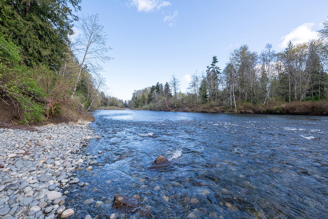
The Morden Colliery Regional Trail (MCRT) is a 4 km-long corridor of Provincial Crown Land located between Morden Colliery Historic Provincial Park in South Wellington and Hemer Provincial Park in Cedar.
In 1995, the Regional District of Nanaimo (RDN) initiated development of the MCRT corridor for recreational trail use under license from the Province of British Columbia. The MCRT runs along an old rail grade used to move coal from the mines of South Wellington to Boat Harbour during the early years of the 20th Century.
Over the past 30 years, under the management of the RDN, this segment of a historical rail corridor has become a popular regional and community route for walking, nature appreciation, horseback riding and cycling.
Because there is currently no bridge crossing the Nanaimo River within the MCRT, the trail network of the MCRT consists of two separate segments:
South Segment: A 1 km-long section between Morden Colliery Historic Provincial Park to the Nanaimo River
North Segment: A 2 km-long section between Cedar Road and Hemer Provincial Park
The Central segment of the MCRT, which runs approximately 1 km through agricultural land from the Nanaimo River to Cedar Road is currently undeveloped and requires two bridges to span the Nanaimo River.
The design of the Nanaimo River and Thatcher Creek bridges will be completed in phases as budget allows:
Phase 1A - Concept Design
Phase 1B - Concept Design Refinement and Class D Cost Estimate
Phase 2 - Detailed Design and Class C Cost Estimate
Phase 3 - Tender Documents and Class B Cost Estimate
Phase 4 - Construction
If approved, the overall scope of proposed works includes:
two new bridge spans over the Nanaimo River;
two new bridges for the Thatcher Creek crossings to replace existing infrastructure;
fenced trail corridor through the agricultural lands;
Want to stay updated about this project?
Sign up for project updates by subscribing and leaving your email address and we will email updates about the project as it progresses
Check out the Project Updates tab below for project updates
The final concept design report has been completed and was presented to the RDN Board on January 13, 2026. The work included a detailed evaluation of existing conditions and a comparative assessment of bridge type options for both the Nanaimo River and Thatcher Creek crossings. At the January 13 meeting, the Board approved the recommendation to proceed to detailed design for a 2.4‑metre‑wide stiffened suspension bridge at the Nanaimo River crossing and a 2.4‑metre‑wide truss bridge at the Thatcher Creek crossing.
The final concept design report has been completed and was presented to the RDN Board on January 13, 2026. The work included a detailed evaluation of existing conditions and a comparative assessment of bridge type options for both the Nanaimo River and Thatcher Creek crossings. At the January 13 meeting, the Board approved the recommendation to proceed to detailed design for a 2.4‑metre‑wide stiffened suspension bridge at the Nanaimo River crossing and a 2.4‑metre‑wide truss bridge at the Thatcher Creek crossing.
The Regional District of Nanaimo Board approved the award of a contract to ISL Engineering and Land Services Ltd. (ISL) for Phase 1A project management and engineering services for the design of the Nanaimo River and Thatcher Creek bridges. Preliminary survey, geotechnical and hydrotechnical investigation work has begun and will be used to inform conceptual design considerations and costing. Recommendations will be presented to the RDN Board for further direction moving forward.
The Regional District of Nanaimo Board approved the award of a contract to ISL Engineering and Land Services Ltd. (ISL) for Phase 1A project management and engineering services for the design of the Nanaimo River and Thatcher Creek bridges. Preliminary survey, geotechnical and hydrotechnical investigation work has begun and will be used to inform conceptual design considerations and costing. Recommendations will be presented to the RDN Board for further direction moving forward.
Page last updated: 20 Feb 2026, 11:33 AM
1999
Morden Colliery Regional Trail has finished this stage
Planning of the Morden Colliery Regional Trail and bridge began and preliminary design and hydrotechnical studies were completed.
2014-2016
Morden Colliery Regional Trail has finished this stage
In 2014, Herold Engineering was retained by the Regional District of Nanaimo to review the site at the Nanaimo River and Morden Colliery Regional Trail to determine the feasibility of constructing a pedestrian crossing.
The Board gave direction for design work to proceed for a steel truss bridge that accommodates pedestrians, cyclists, equestrians and those using medical mobility aids.
2018-2020
Morden Colliery Regional Trail has finished this stage
The Agricultural Land Commission (ALC) issued conditional approval to the development of a one-kilometre trail through Agricultural Land Reserve.
2021-2023
Morden Colliery Regional Trail has finished this stage
The Province of British Columbia offered a License of Occupation to permit the RDN continued use of the corridor for regional trail use and to conduct a survey of the land.
In 2023, the boundary survey was completed and has been registered by the Surveyor General and submitted to the province.
An updated feasibility study was undertaken to review the bridge crossing over the Nanaimo River, resulting in the recommendation for two distinct bridge spans of 110m and 100m.
2024
Morden Colliery Regional Trail has finished this stage
A Request for Proposals (RFP) for engineering services for the design of Morden Colliery bridges was publicly posted and awarded to ISL Engineering Ltd.
2025
Morden Colliery Regional Trail has finished this stage
Phase 1A - Concept Design is complete and recommendations were presented to the RDN Board on January 13, 2026.
2026
Morden Colliery Regional Trail is currently at this stage
Following approval by the RDN Board, the Nanaimo River and Thatcher Creek bridge projects are advancing to the next stage of concept refinement and detailed design.
2027 and beyond
this is an upcoming stage for Morden Colliery Regional Trail
Subject to RDN Board approval, the project will proceed with tender document preparation and construction of the Nanaimo River and Thatcher Creek bridges.