River’s Edge Water Quality Improvement Project

Background
The Regional District of Nanaimo (RDN) owns and operates the River’s Edge Water Service Area (REWSA), located off Kaye Road, in Electoral Area G, to the southeast of Parksville, B.C. To address the increasing trend of saltiness in the local groundwater aquifer, the RDN has embarked on the River's Edge Water Quality Improvement Project, a project that involves drilling additional water supply wells and installing transmission mains and related infrastructure. The RDN carried out extensive public engagement in 2024, leading up to a petition process being held to gain electoral assent for the borrowing required to fund the project. The petition received overwhelming support from the residents in the REWSA and the RDN Board of Directors officially adopted Borrowing Bylaw No. 1914 on January 14, 2025.
Well Drilling
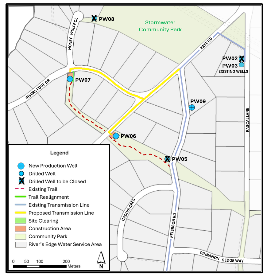
Five new groundwater production wells were drilled in 2025 (PW05-PW09) as shown in the image below. The well drilling locations were recommended by the project hydrogeologist based on the thickness of the local aquifer, distance of the wells from each other, groundwater flow direction, and reviewing the available groundwater quality information. Pump testing was completed in early 2026 and the hydrogeologist has recommended that three of the five test wells (PW06, PW07, and PW09) be connected to the River's Edge water system. Once the new wells are in operation, the pumping rate in well PW03 will be reduced from 75-80 USGPM to 20 USGPM, and PW02 will be removed from service.
Construction Expected to Begin in Sept/Oct 2026
Engineered design drawings have been prepared for the water transmission mains, power, and control infrastructure required to bring all three new wells into operation. A construction tender was publicly posted on June 3, 2026, to invite qualified contractors to submit bids for the construction and commissioning work. The contract is expected to be awarded in August 2026, after which the construction start date will be shared with the community.
The RDN plans to register statutory right of ways (SRWs) at each successful well site (PW06, PW07, and PW09). At the locations of PW05 and PW08, where water quality or quantity was insufficient to meet the project objectives, these test wells will be decommissioned as part of the park land restoration process later in 2026.
Costs to Property Owners
The well drilling project is being funded by the 157 property owners in the River’s Edge Water Service Area. The final amount owing will depend on the lending rate in place at the time of borrowing. Lending rates tend to fluctuate from year to year, and the project will take more than one year to complete from its start date. Using an estimated Municipal Finance Authority lending rate of 4.6% and a 25-year amortization period would result in a cost of $15,546 per property, or an estimated annual debt repayment of $1,110 for each of the 157 properties in the River’s Edge Water Service Area.
No project costs will be payable by the River’s Edge property owners until the well drilling and connection mains have been constructed and all costs have been accounted for. Owners will be given the option to pay their share of the project costs as a lump sum (to avoid interest charges) or to amortize the amount on their taxes for 25 years.
Once the debt amount has been added to a property's tax roll, it cannot be removed or paid off early. It will stay as a water quality improvement charge on the property for the stated repayment period of 25 years (i.e., even if the property is sold).
For more information and to Get Involved:
- Visit our What's New updates that will share information on this page as the project moves forward.
- Explore the document library on this webpage to find out more about the proposed water quality protection project.
- Stay informed by clicking on subscribe, to leave your email address and receive email updates as the project moves forward.
- Check out the FAQ's which provide answers to common questions on the proposed project;
- Ask a question and we will do our best to answer it and share the information with all.
-
Well Drilling Update - February 2026
Well Drilling Update - February 2026
Work Completed
The Project Hydrogeologist has recommended that three of the five test wells (PW06, PW07 and PW09) be connected to the River’s Edge water system to meet the project objective of minimizing chloride intrusion into the aquifer.
Adding PW06, PW07 and PW09 will allow the Regional District of Nanaimo (RDN) to better manage pumping rates and operating schedules to maintain a healthy aquifer. Once the new wells are in operation, pumping from existing well PW03 will be reduced from 75–80 USGPM to 20 USGPM and PW02 will be removed from service.

The well driller is currently installing pumps and pitless adapters in the new wells. This work is consistent with installations used at other RDN well sites.
Next Steps
The Project Hydrogeologist is finalizing the well drilling and testing report and well protection plan, expected in March 2026. This documentation will support the RDN’s application to Island Health for drinking water source approval.
In parallel, an engineering consultant is preparing design and tender specifications for the infrastructure required to connect the new wells to the River’s Edge water system. Following source approval (anticipated in May 2026), the RDN will apply for construction permits from the Ministry of Transportation, Island Health, and the RDN Parks Department. A public tender for water transmission main construction will be issued once all permits are in place.
-
Well Drilling Update - December 2025
Thank you for your cooperation over the summer and fall months while we completed the well drilling and testing phase of the project.
Work Completed
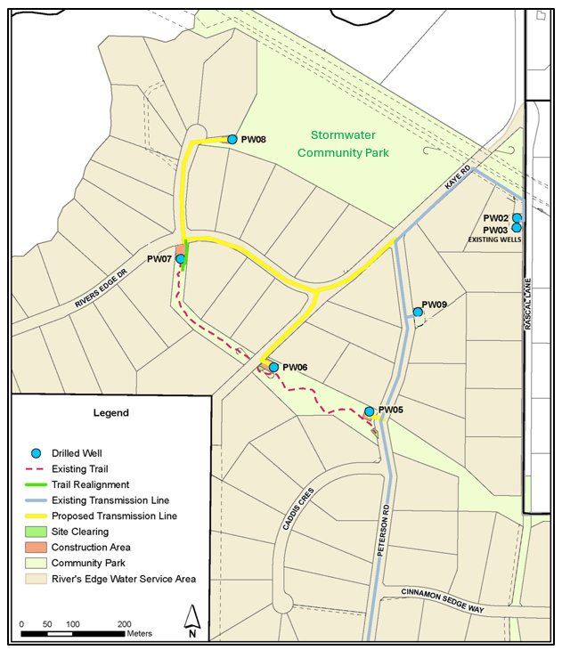
The Regional District of Nanaimo (RDN) has completed the well drilling, development, pump testing and water quality testing of five new wells. This includes PW09, an extra well drilled in addition to the four initial wells planned in this project. The well locations are shown on the map below.
The long-term continuous and sustainable pumping rates (safe yields) at low ground water level conditions and the safe yields at intermittent or high groundwater conditions are given in the table below.
Well #
Well Location
Safe pump yield at low groundwater level conditions (i.e. summer)(USGPM)
Safe pump yield at high groundwater level conditions (i.e. winter) (USGPM)
PW05
2325 Peterson Rd
4
8
PW06
2300 Kaye Rd
35
48
PW07
880 River’s Edge Dr
8
17
PW08
Stormwater Community Park
N/A
N/A
PW09
2260 Peterson Rd
30
55
Well # PW08, located in the Stormwater Community Park near Honey Wulff Close, was pump tested at 7.5 USGPM. Although the well was able to sustainably produce water, the aquifer at this location was found to have a significant hydraulic connection between the lower and middle aquifer. Since this project is intended to minimize chloride intrusion from the lower aquifer into the middle aquifer, and pumping this well (PW08) would be counterproductive to that objective, it was decided not to bring PW08 into operation.
Chloride concentrations in all of the RDN’s River’s Edge production wells were checked at different pumping durations to gain an in-depth understanding of the hydraulic connections between the middle aquifer and lower aquifer at each well location, and to determine whether short vs. long pumping durations would trigger a significant rise in chloride levels. A summary of chloride concentrations is given in the table below.
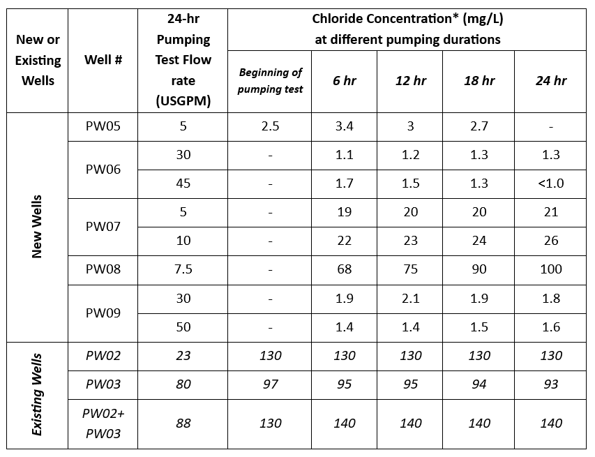 * The taste threshold for chloride in drinking water is 250 mg/L, for plant health it’s 100 mg/L, and the indicator of saltwater intrusion potential is 150 mg/L.
Next Steps
The Project Hydrogeologist is currently analyzing the data to determine whether connecting each new well to the River’s Edge water system will meet the overall project objective of minimizing chloride intrusion. He will also recommend a safe, sustainable operating schedule for the wells. The final hydrogeological report will be completed in March 2026 and the RDN will include this report in an application to Island Health for source approval of the new wells. Once the source approval has been received, the RDN will issue a competitive tender for construction of the watermains, power, and control works that would bring the new wells into operation. While waiting for the source approval, the RDN has retained MPE Engineering to undertake the survey, design work, tender specifications, and permit applications. MPE will also provide construction supervision once construction begins.
Anticipated Project Timeline
- Surveying and pump design – December 2025 to February 2026
- Completion of hydrogeological analyses and reporting – February/March 2026
- Completion of design and tender specifications for watermains and power/control infrastructure – March/April 2026
- Confirmation of Island Health source approval – April/May 2026
- Construction permits received from Island Health and Ministry of Transportation and Transit – May 2026
- Tender invitation – May/June 2026
- Construction begins – August 2026
- Construction is complete – March 2027
- Property owners indicate their intended debt repayment option to RDN (as one lump sum or tax amortization of project costs) – June/July 2027
- Project is closed – September 2027
-
Well Drilling Update - September 2025
Thank you for your cooperation over the summer months during the well drilling and testing.
Work Completed
The Regional District of Nanaimo (RDN) completed the well drilling and well screen development of four new groundwater wells at the locations shown in the map image below. Twenty-four-hour pumping tests of PW06 and PW07 were completed in early September 2025, and the twenty-four-hour pumping tests of the other two wells, PW05 and PW08 will be completed by mid-September 2025. The long-term continuous and sustainable pumping test rate (safe yield) from each well will be determined after the completion of all the pumping tests. Based on the safe yield from each well, an appropriate well pump and motor will be ordered and installed.
The preliminary analyses, based on the completed twenty-four-hour pumping tests of PW06 and PW07 and the short pumping tests of PW05 and PW08, show that the safe yield of PW06 would be approximately 30 United States Gallons Per Minute (USGPM) and the other three wells would be approximately 5 USGPM each. Since the RDN's initial plan was to withdraw a total of 60 USGPM from these new wells, this leaves a shortfall of approximately 10-15 USGPM production rate. To accommodate this shortfall, an additional well will be drilled, PW09.

Next Steps
PW09 will be drilled at one of the RDN's existing well sites, PW01, near 2260 Peterson Road (see photo below). The existing wells at this site were completed in the lower aquifer and they are only being used for monitoring purposes. The new well at this site will be completed in the middle aquifer layer where the good drinking water source is located. Considering there is already a transmission main installed at this site which could be connected to the new well, and the RDN has a utility right-of-way at this site requiring almost no additional site preparation for the new well, PW09 can be drilled and brought into operation within the existing budget. Additionally, having PW09 drilled as part of the ongoing drilling project reduces the contractor's mobilization and demobilization costs allowing the drilling, development and pumping tests to be completed at the competitive tender rate obtained for the other four wells. The drilling, development and pumping test of PW09 is planned to be completed by October 31, 2025.

The RDN is also in the process of retaining an engineering consultant to provide survey, design and construction supervision for the civil, structural, mechanical, electrical, instrumentation and control/automation aspect of the transmission mains and well site infrastructure for all of the wells completed in this project. The construction of this phase is tentatively planned to begin in the summer of 2026.
-
Well Drilling to Begin June 30, 2025
Date: June 30 to September 30, 2025
Time: 8 a.m. to 4:30 p.m.
Well drilling will begin on June 30, 2025 at the PW05 Peterson Road site (please see the map below for well drilling sites). One well is expected to be drilled at each of the four prospective well sites between June 30 and September 30, 2025.
The well drilling crew will move from PW05 to PW06, then PW07 and lastly PW08. Once the wells are drilled, the crew will move between each site to complete other drilling activities such as setting the well screens, and carrying out the pump tests, etc.
The well drilling is not expected to affect park users, however, for your safety and the safety of the work crew, please remain alert to work activities and obey any posted signs. While low levels of construction noise from the well drilling equipment can be expected, there will be no disruption to local traffic.

For more information, please contact:
Water Services, Regional District of Nanaimo
Ph. 250-248-4914
Email rcu@rdn.bc.ca
-
Site Clearing in Park Land Continuing
Date: May 9 - 16, 2025 (including the weekend)
Time: 8 a.m. to 4:30 p.m.
Trail Closure: May 9 - 16, 2025 at Kaye River’s Edge Community Park
As part of the Well Drilling Project, site clearing will continue to take place at the four well drilling sites in River’s Edge, as identified on the site map below. The tree-falling work is complete, and the next step is to remove the tree stumps, clear the brush and level the soil at the well sites.
Brush-clearing at the sites of PW05, PW06 and PW08 will not affect park users, however, the park trail at site PW07 will be temporarily closed for five to seven days while stump removal is underway. The temporary park trail closure will be marked with signs at both entrances to the trail. As part of the well site preparation, the trail will be realigned temporarily near PW07 to ensure that park use may safely resume.
Brush-clearing and stump removal work is expected to begin on Monday, May 12, 2025, and will take place during daylight hours. Intermittent noise from a small excavator can be expected. No interruption to traffic flow on the roadway is expected. For your safety and the safety of the work crew, please remain alert to work activities and obey any posted signs.
Signup Banner

Document Library
-
 June 2025 Parks and Trails Alert - Well Drilling to begin June 30 (485 KB) (pdf)
-
May 2025 Parks and Trails Alert - Stump and Brush clearing - Rivers Edge (509 KB) (pdf)
-
April 2025 Parks and Water Services Alert - Construction Tree Falling - Rivers Edge Park Trails.pdf (499 KB) (pdf)
-
Staff Report - Statutory Right of Way on Park land to Drill Wells.pdf (1.52 MB) (pdf)
-
Rivers Edge Chloride Graph 2002-2024.png (56.2 KB) (png)
-
RE Seasonal Water Consumption 2019-2023 (174 KB) (pdf)
-
Rivers Edge Aquifer Profile (345 KB) (pdf)
-
Rivers Edge Water Service Area Boundary MAP (915 KB) (pdf)
-
What We Heard Engagement Summary Report- REWSA (363 KB) (pdf)

FAQ's
-
 Water Quality Improvement Project
- Why is the quality of groundwater deteriorating in this area?
- How can I reduce my water consumption?
- How is drinking water currently supplied to this service area?
- What is an aquifer?
- What would happen if no changes are made?
- What does the RDN propose to solve this problem?
- What are the steps involved in the process of installing more wells?
- If the project does not proceed or fails due to insufficient production from the new wells, would individual property owners have the option to drill wells on their own properties?
- What if the new test wells being drilled fail to meet the required gallons per minute necessary to supplement the existing wells?
- Who established the REWSA and put in place the water infrastructure? Why was this water quality issue not planned for?
- Can water be used from another source instead of drilling new wells?
- Will River's Edge go to permanent Stage 4 watering restrictions?
- Does the drinking water currently pose a health risk to residents?
- Could property owners install reverse osmosis systems in their own homes?
-
Petition Process and Financing
- What is the petition process and why is it being used for this project?
- Who can participate in the petition process?
- What should I do if I support this project?
- What should I do if I oppose this project?
- What happens if this petition passes?
- What happens if this petition fails?
- Who pays for this proposed project and what is the expected cost?
- Why is the repayment amount only an estimate?
- Who is the Municipal Finance Authority?
- If the project goes ahead, when do I have to pay my share of the costs?
- What happens if the project goes over budget?
- If this projects gains petition approval and I was opposed to the project, do I still have to pay?
- What if I don't want my taxes to increase?
- If a property owner opts to spread the cost of the project over their yearly taxes and subsequently sells the property, would the outstanding debt transfer to the new owners?
- What if I change my mind and want to pay off the annual tax amount 5 years later?
- What are the details of the project budget?
-
Water Usage in River's Edge
- I have other questions, who can I ask?

Who's Listening
-

Email dchurko@rdn.bc.ca -

Email jmccallum@rdn.bc.ca